In OK-FIRE there are 9 available NFDRS (National Fire Danger Rating System) fuel models. These models are based off the 1988 NFDRS fuel models. Most have been modified in part to be more realistic for Oklahoma landscapes and climate conditions. The models that have not been modified are B, F, G, and K. Here are the 9 available fuel models:
- Grassy Models
- A — Western annual grasses / annual cropland / urban
- L — Western perennial grasses
- T — Tallgrass with open evergreen brush
- Brushy Models
- B — Tall dense evergreen brush / eastern redcedar
- F — Intermediate evergreen brush
- Forest Models
- G — Forest with heavy downed fuels
- P — Southern pine forest
- R — Hardwood forest
- Slash Model
- K — Light slash
It is important to understand that for fire danger map products (Burning Index, Spread Component, Energy Release Component, and Ignition Component) there is a default fuel model associated with each 500-meter pixel of land, and that fuel model distribution cannot be changed. Each pixel of land in Oklahoma is represented by one of the following seven fuel models: A, B, F, L, P, R, and T. The “default fuel model” for any given Mesonet site is the fuel model of the pixel in which the Mesonet site is located.
However, for chart, table, and home page data columns, the OK-FIRE user can change the “default fuel model” for any given Mesonet site to a different fuel model (any of the nine available models). The new model will then become the “current fuel model” for that site and will remain so until changed again. Fire danger output for these site-specific products is based on the “current fuel model”, which is either the user-assigned fuel model or the default fuel model if not changed. For the primary Mesonet site on the home page (first column of station data to the right of the two regional maps), the fuel model can be changed directly near the bottom of left menu section via the pull-down fuel model list. For all other Mesonet sites, the fuel models can be changed on the “Station Fuel Model Options” page, whose link appears at the very bottom of the left menu section on the home page. For the vast majority of Oklahoma landscapes, seven fuel models should suffice (A, L, T; B, F; and P, R). Model G (forest with heavy downed fuels) and Model K (light slash) should be used only if the landscape warrants.
For more information about fuel model parameters, see the fuel model parameter table (PDF).
Grassy Models
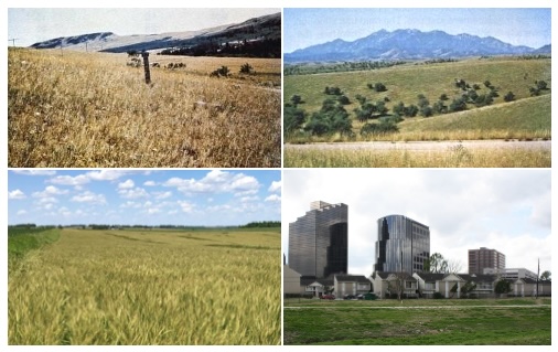
In the NFDRS this model is used to represent western grasslands vegetated by annual grasses and forbs. Brush or trees may be present but are very sparse, taking up less than one-third of the area. Open pinyon-juniper, sagebrush-grass, and desert shrub associations may be assigned this fuel model if the woody plants meet the density criteria. The quantity and continuity of the ground fuels vary greatly with rainfall from year to year.
In OK‑FIRE we also use Model A to represent areas of annually planted agricultural crops such as wheat, canola, and cotton. There is no NFDRS fuel model for such agricultural landscapes (most fire danger systems classify such lands as either "agriculture" or "non-burnable" and ignore them in fire danger rating). However, we wanted to have all burnable pixels in Oklahoma be associated with a fuel model so that fire danger is calculated for all areas. Admittedly, associating this fuel model with such cropped landscapes is risky as the fuel model will, under appropriate weather conditions, result in fire danger even after the crops have been harvested and the land tilled; this fuel model may also underestimate fire danger as some crops will have heavier fuel loads. Having the lowest fuel loads of any grassy model, it will also under most weather conditions give lower burning indices than the other grassy models L and T, which are used for rangelands and pastures, so it is a good compromise to produce some fire danger but not as much as with other grassy fuel models.
We also use Model A to represent urban areas with their lawns, parks, and other vegetation that is typically low in fuel loading.
Model A consists of only 1‑hour dead fuels (0.2 ton/acre residual load) and live herbaceous fuels (0.3 ton/acre). It has a modeled fuel bed depth of 0.8 foot and no drought fuel load. The dead fuel moisture of extinction is 15% and typical spread rate under severe burning conditions is 301 feet/minute, the fastest of any of the NFDRS models. This fuel model correlates to the Anderson (1982) fire behavior fuel model 1, although that model has no live fuel load.
Model L is the fuel model which is used in much of the panhandle and western Oklahoma to represent medium‑height grass prairie. In the NFDRS it is used to represent western grasslands vegetated by perennial grasses. The principal species are coarser and the loadings heavier than those in Model A fuels. Otherwise the situations are very similar; shrubs and trees occupy less than one‑third of the area. The quantity of fuels in these areas is more stable from year to year.
Model L, like Model A, consists of only 1‑hour dead fuels (0.25 ton/acre residual load) and live herbaceous fuels (0.5 ton/acre). It has a modeled fuel bed depth of 1.0 feet and no drought fuel load. The dead fuel moisture of extinction is 15% and the typical spread rate under severe burning conditions is 178 feet/minute. This fuel model also correlates to the Anderson (1982) fire behavior fuel model 1, although that model has no live fuel load.
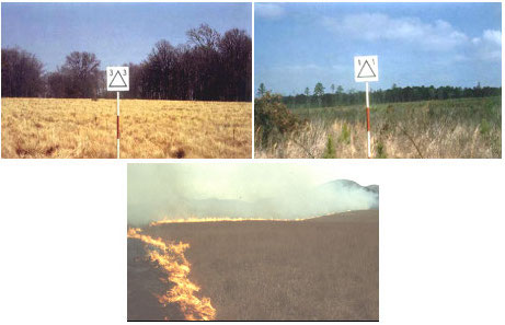
This is the fuel model which is used for much of central and eastern Oklahoma to represent tallgrass prairie with intermixed evergreen brush, including cedar trees. In the NFDRS it is used to represent sagebrush‑grass fuels of the Great Basin and Intermountain West. The shrubs burn easily and are not dense enough to shade out grass and other herbaceous plants. As originally designed, the model specifies that the shrubs should occupy at least one‑third of the area.
Model T contains both 1‑hour dead fuels (0.75 ton/acre residual load) and 10-hour dead fuels (0.5 ton/acre), as well as a significant live woody load (2.5 tons/acre) and a live herbaceous load (1.25 tons/acre). It has a modeled fuel bed depth of 1.39 feet and a drought fuel load of 0.5 ton/acre. The dead fuel moisture of extinction is 15% and the typical spread rate under severe burning conditions is 96 feet/minute. This fuel model correlates to the Anderson (1982) fire behavior fuel model 2.
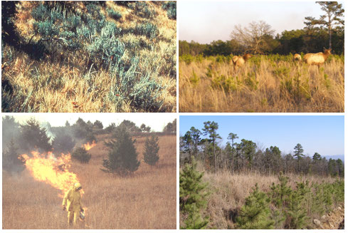
Brushy Models
This NFDRS model is used to represent mature dense fields of evergreen brush 6 feet or taller in height. One‑fourth or more of the aerial fuel in such stands is dead. Foliage burns readily under appropriate conditions. Model B fuels are potentially very dangerous, fostering intense fast‑spreading fires. This model was originally developed for California mixed chaparral but can be used for other dense tall evergreen brush. In OK‑FIRE we also use it to represent areas dominated by closed stands of eastern redcedar.
Model B contains 1‑hour dead fuels (3.5 tons/acre residual load), 10‑hour dead fuels (4.0 tons/acre), and 100‑hour dead fuels (0.5 tons/acre) as well as a very heavy live woody evergreen load (11.5 tons/acre) but with no live herbaceous load. It has a modeled fuel bed depth of 4.5 feet (average) and a drought fuel load of 3.5 tons/acre. The dead fuel moisture of extinction is 15% and the typical spread rate under severe burning conditions is 58 feet/minute. This fuel model correlates to the Anderson (1982) fire behavior fuel model 4.
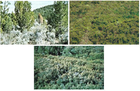
This NFDRS model is used to represent mature closed chamise stands and oakbrush fields of Arizona, Utah, and Colorado. It also applies to young, closed stands and mature, open stands of California mixed chaparral. Open stands of pinyon‑juniper are represented; however, fire activity will be overrated at low wind speeds and where ground fuels are sparse. In OK‑FIRE it is used to represent heavy evergreen brush such as found in southwest Oklahoma. The vegetation is not as tall as in Model B and fuel loads are less.
Model F contains 1‑hour dead fuels (2.5 tons/acre residual load), 10‑hour dead fuels (2.0 tons/acre), and 100‑hour dead fuels (1.5 tons/acre) as well as a heavy live woody load (7.0 tons/acre) and a live herbaceous load (1.0 ton/acre). It has a modeled fuel bed depth of 4.5 feet and a drought fuel load of 2.5 tons/acre. The dead fuel moisture of extinction is 15% and the typical spread rate under severe burning conditions is 24 feet/minute. This fuel model correlates to the Anderson (1982) fire behavior fuel model 6. At moderate wind speeds, fires carry through the shrub layer but fire will drop to the ground at low wind speeds or openings in the stand.
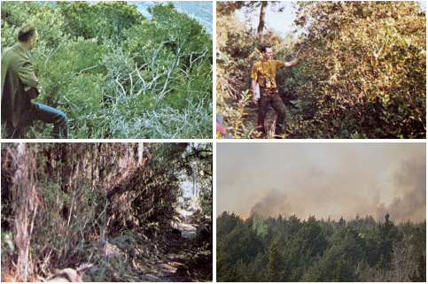
Forest Models
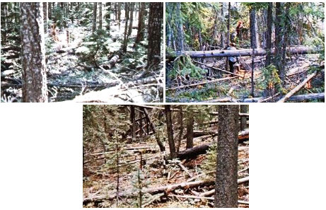
This NFDRS fuel model is used for dense conifer stands where there is a heavy accumulation of litter and downed woody material. Such stands are typically overmature and may also be suffering insect, disease, and wind or ice damage—natural events that create a very heavy buildup of dead material on the forest floor. The duff and litter are deep and much of the woody material is more than 3 inches in diameter. The undergrowth is variable, but shrubs are usually restricted to openings. Types to be originally represented by Model G are hemlock‑Sitka spruce, coastal Douglas fir, and wind‑thrown or bug‑killed stands of lodgepole pine and spruce. However, any forest type (including deciduous) may be considered if heavy downed material is present. Only the understory fuels are modeled. Model G is often the "standard" fuel model used in national fire danger forecasting, especially in the western United States. However, Model G is not typical of Oklahoma forests and should only be used if the landscape warrants.
Of all the fuel models offered on OK‑FIRE, Model G has the greatest loadings for 100‑hour and 1000‑hour dead fuels (representative of the heavy downed material). The model contains 1‑hour dead fuels (2.5 tons/acre residual load), 10‑hour dead fuels (2.0 tons/acre), 100‑hour dead fuels (5.0 tons/acre), and 1000‑hour dead fuels (12.0 tons/acre). It has a small live woody fuel load (0.5 ton/acre) and live herbaceous load (0.5 ton/acre). Model G has a modeled fuel bed depth of 1.0 foot and a large drought fuel load of 5.0 tons/acre. The dead fuel moisture of extinction is 25% and the typical spread rate under severe burning conditions is 30 feet/minute. This fuel model correlates to the Anderson (1982) fire behavior fuel model 10. Fires in this fuel complex burn with greater intensity than do fires in the other OK‑FIRE forest fuel models (P, R).
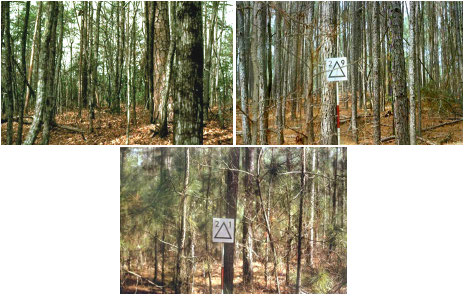
This is the fuel model which is used in southeast Oklahoma to represent coniferous pine forests. Only the understory fuels are modeled. In the NFDRS this model is used to represent closed stands of long-needled southern pines. A 2- to 4-inch layer of lightly compacted needle litter is the primary fuel. Some small diameter branch wood is present, but the density of the canopy precludes more than a scattering of shrubs and grass.
Model P contains 1‑hour dead fuels (0.75 ton/acre residual load), 10‑hour dead fuels (0.75 ton/acre), and 100‑hour dead fuels (0.5 ton/acre) as well as a live woody load (0.5 ton/acre) and live herbaceous load (0.5 ton/acre). It has a modeled fuel bed depth of 0.34 feet and a drought fuel load of 1.0 ton/acre. The dead fuel moisture of extinction is 20% and the typical spread rate under severe burning conditions is 14 feet/minute. This fuel model correlates to the Anderson (1982) fire behavior fuel model 9.
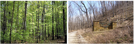
This is the fuel model which is used over much of central and eastern Oklahoma to represent deciduous hardwood forests. Only the understory fuels are modeled. Model R should be used in all hardwood and mixed conifer‑hardwood stands where more than half of the overstory is deciduous.
In the 1978 and 1988 NFDRS, there were two hardwood forest models, R and E, with the first (R) representing "summer" fuel conditions between canopy leaf out in the spring and leaf fall in the autumn and the latter (E) representing "winter" fuel conditions after leaf fall in the autumn and before leaf out in the spring. However, with the use of daily satellite information to assess greenness levels, OK‑FIRE now only uses one fuel model, R, to represent hardwood forests since fuel conditions throughout the year can be simulated based on greenness levels.
Model R contains 1‑hour dead fuels (0.67 ton/acre residual load), 10‑hour dead fuels (0.5 ton/acre), and 100‑hour dead fuels (0.5 ton/acre) as well as a live woody load (0.66 ton/acre) and live herbaceous load (0.67 ton/acre). It has a modeled fuel bed depth ranging from 0.3 to 0.37 feet, depending on seasonal fuel conditions, and a drought fuel load of 1.0 ton/acre. The dead fuel moisture of extinction is 20% and the typical spread rate under severe burning conditions ranges from 6 to 25 feet/minute, depending on seasonal fuel conditions. This fuel model correlates to Anderson (1982) fire behavior fuel model 8 for summer conditions and fuel model 9 for winter conditions.
Slash Model
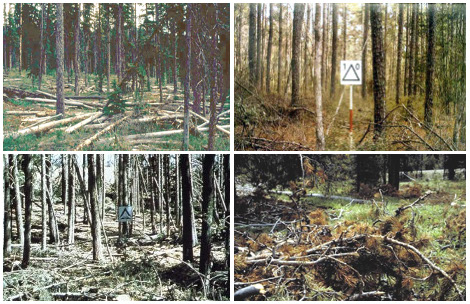
This is the only slash model in our suite of 9 NFDRS fuel models. Fuel Model K represents slash fuels from light thinnings and partial cuts in conifer stands. Typically the slash is scattered about under an open understory. This model applies also to hardwood slash and to southern pine clearcuts where the loading of all fuels is less than 15 tons/acre. Like Model G, this fuel model should only be used when the landscape warrants.
Model K contains all categories of dead fuels: 1‑hour dead fuels (2.5 tons/acre load), 10‑hour dead fuels (2.5 tons/acre), 100‑hour dead fuels (2.0 tons/acre), and 1000‑hour dead fuels (2.5 tons/acre). It has NO live woody or herbaceous fuel loads. Model K has a modeled fuel bed depth of 0.6 feet and a drought fuel load of 2.5 tons/acre. The dead fuel moisture of extinction is 25% and the typical spread rate under severe burning conditions is 23 feet/minute. This fuel model correlates to the Anderson (1982) fire behavior fuel model 11.